


Guatemala’s high country is defined by steep volcanic cones and rugged ridges that rise sharply above lush valleys and colonial towns. These peaks are mostly stratovolcanoes with rocky, often loose volcanic scree slopes, demanding strong legs and steady footing. The skyline is dominated by active volcanoes like Fuego, whose eruptions punctuate the night sky, making overnight summit camps a rare and intense reward. This is a volcanic landscape where altitude and activity shape every climb and view.
Among the 13 key peaks, Acatenango stands out for its overnight camp that offers direct views of Fuego’s eruptions, while Tajumulco claims the highest elevation in Central America at 13,845 feet / 4,220 m. Moderate climbs like Pacaya provide accessible lava fields, contrasting with the expert-only Fuego summit. If the goal is a summit with volcanic spectacle and physical challenge, this guide is essential; if casual day hikes or easy viewpoints are the priority, look elsewhere.
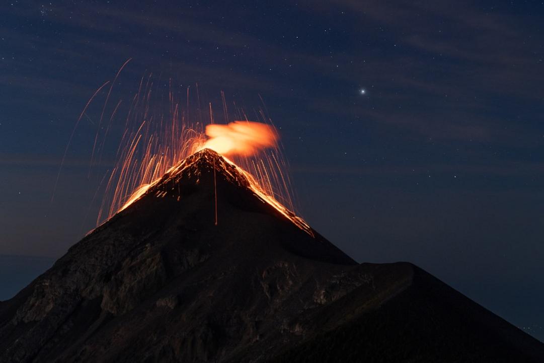
Key takeaways
- Choose Volcán Acatenango for the best overnight eruption viewing experience near Antigua.
- Skip Volcán San Pedro’s summit for views; Indian Nose sunrise offers better panoramas with less effort.
- Plan Tajumulco climbs between November and April for clear summit sunrises above the clouds.
- Expect a hard 10 – 12 hour round trip on Acatenango, including an overnight camp near 13,000 feet / 3,960 m.
- Avoid solo attempts on Volcán de Fuego; active eruptions require mandatory guides and up-to-date safety checks.
- Pacaya’s 3-hour moderate hike offers fresh lava fields but skip the summit crater due to instability.
- Volcán Santa María’s single-day climb rewards with views of the continuously active Santiaguito dome below.
- Prepare for thin air above 12,000 feet / 3,660 m on Tajumulco; acclimatize if possible to avoid altitude sickness.
The peaks at a glance
| Peak | Type | Region | Effort | Why it is on the list |
|---|---|---|---|---|
| Acatenango | High-altitude stratovolcano | Antigua area | Hard 10-12h hike with camp | Overnight camp with direct views of Fuego eruptions |
| Fuego | Active stratovolcano | Antigua area | Expert guide-only summit climb | Frequent eruptions with ash plumes every 15-60 minutes |
| Agua | Steep volcanic cone | Antigua area | Moderate 4h day hike | Summit views over Antigua and Volcán de Fuego |
| Tajumulco | Extinct stratovolcano, highest peak | San Marcos | Hard 6-8h round-trip hike | Summit sunrise above 13,800 feet / 4,210 m with highland panoramas |
| Cerro Azul | Forested high peak | Western Highlands | Moderate 4-6h hike | Clear summit ridge views before morning clouds |
| Pacaya | Active lava field volcano | Near Guatemala City | Moderate 3h guided hike | Walk on fresh lava less than a year old |
| Volcán Tajumulco | Extinct stratovolcano, highest point | San Marcos | Hard 2-day trek with summit camp | Sunrise above clouds with views to Mexico’s Tacaná |
| Volcán Tacaná | Active stratovolcano with fumaroles | Mexico border | Hard multi-day climb | Technical sulfur-fumarole zone near summit |
| Volcán Acatenango | High stratovolcano with eruption views | Antigua area | Hard 24h camp climb | Night eruption show of Volcán de Fuego from camp |
| Volcán de Fuego | Continuously active stratovolcano | Antigua area | Expert guide-only ascent | Ash and lava eruptions every 15-60 minutes |
| Volcán Santa María | Stratovolcano with active dome | Quetzaltenango area | Hard single-day climb | Views of continuously active Santiaguito dome |
| Volcán Atitlán | Steep stratovolcano | Lake Atitlán rim | Hard 6-8h climb | Steep ascent with lake views from south rim |
| Volcán San Pedro | Extinct cloud forest volcano | Lake Atitlán rim | Moderate 4-5h hike | Workout climb with jungle-covered summit and no views |
Where the peaks are
Every peak in depth
Prefer a guide for the harder climbs? Local operators run permitted, guided trips on the peaks below.
Acatenango – Hard Overnight Climb for Eruption Views

- Elevation: 3976 m
- Climb: hard
- Volcano: last erupted 1972
Expect a steep, rocky trail with loose volcanic scree underfoot, demanding strong legs and steady pacing. The thin air near the summit tests endurance, especially on the final push. Camp at El Porvenir near the summit to catch Fuego’s eruptions lighting the night sky. The 12-hour round trip splits best with an overnight stay to avoid afternoon storms and gain the full eruption spectacle. Sunrise from the summit reveals a raw volcanic landscape and distant highland peaks. Skip daytime-only attempts; the eruption show happens after dark and is worth the extra effort.
How this peak formed
Acatenango is a stratovolcano formed by layered lava and ash deposits, part of the Sierra Madre range. It stands adjacent to Fuego, Guatemala’s most active volcano, allowing safe viewing of eruptions from its summit camp. The high-altitude environment features sparse vegetation and volcanic rock debris. Last erupting in 1972, Acatenango’s crater is dormant but shaped by past explosive activity. The proximity to Fuego’s frequent eruptions makes Acatenango unique for witnessing volcanic forces without exposure to danger.
What to see (5)
- ▸ Camp overnight at El Porvenir for close-up views of Fuego’s eruptions
- ▸ Watch Fuego’s lava fountains and ash plumes from a safe summit ridge
- ▸ Catch sunrise illuminating Guatemala’s volcanic highlands from 3,976 meters
- ▸ Observe volcanic rock formations and hardened lava flows near the summit
- ▸ Experience the stark transition from forested lower slopes to barren volcanic terrain
Avoid the popular main trail’s summit camp by camping at a quieter ridge spot slightly off the standard route for more privacy.
Bring a headlamp and warm layers for the night camp; eruption views happen after dark and temperatures drop sharply.
Fuego – Expert-Guided Active Volcano Ascent

- Elevation: 3763 m
- Climb: hard
- Volcano: last erupted 2023
Climbing Fuego demands technical respect with steep, unstable volcanic ash and rock slopes. The air thins quickly near the summit, and frequent volcanic activity adds unpredictability. The climb is strenuous, requiring expert guides who monitor current eruption conditions and avoid dangerous zones. Start before 06:00 to beat afternoon storms and catch sunrise with ash plumes lighting the sky. Expect ashfall and strong sulfur smells near the crater rim. Skip solo attempts; the terrain and activity level make this a high-risk climb.
How this peak formed
Fuego is one of Central America’s most active stratovolcanoes, erupting frequently with ash and lava fountains. Its summit crater regularly emits ash plumes visible from Antigua. The volcano formed through successive lava flows and explosive eruptions, creating steep slopes of basaltic rock and volcanic ash. Last erupting in 2023, Fuego’s activity shapes the surrounding landscape with fresh lava fields and pyroclastic deposits. Gas emissions and heat persist near the summit, requiring caution and real-time monitoring.
What to see (5)
- ▸ Watch ash plumes erupting every 15-60 minutes from the active summit crater
- ▸ Experience sulfur gas vents and fresh lava flows near the upper slopes
- ▸ View Antigua and surrounding volcanoes under ash-covered skies
- ▸ Capture sunrise silhouettes of volcanic smoke against the highland backdrop
- ▸ Observe the sharp volcanic ridges sculpted by recent eruptions
Use less common guide outfits that take the eastern approach for a quieter ascent and fewer groups at key viewpoints.
Carry a dust mask and goggles to protect from ash, and confirm eruption activity status with your guide on the morning of the climb.
Agua – Steep Cone with Panoramic Antigua Views
- Elevation: 3760 m
- Climb: moderate
- Volcano: last erupted 1541
The trail climbs steeply over rocky volcanic scree and dirt paths, demanding strong legs and steady breathing. The air thins slightly but remains manageable for those with good fitness. Start early to avoid heat and afternoon storms common after 10 AM. The summit rewards with clear views over Antigua and neighboring volcanoes, including Fuego’s frequent eruptions. The hike takes about four hours round trip, making it a tough but doable day effort. Skip guided tours that only drive around; hiking independently or with a local guide offers real summit payoff.
How this peak formed
Volcán de Agua is a classic volcanic cone formed from layers of hardened lava and ash. Its steep slopes rise sharply over Antigua, shaped by a catastrophic collapse in 1541 that created a large crater now filled with forest. The volcano is dormant but geologically active in the past, composed mainly of andesitic rock. The summit ridge exposes volcanic boulders and sparse highland vegetation. Its position in the Sierra Madre volcanic chain makes it a dominant feature above the city.
What to see (5)
- ▸ Summit viewpoint offering clear morning vistas over Antigua and Fuego volcano
- ▸ Climb through volcanic scree slopes with distinct andesitic rock formations
- ▸ Pass through dense pine and oak forest on lower slopes
- ▸ Observe the 1541 collapse crater rim from the summit ridge
- ▸ Spot local bird species common to highland volcanic environments
Avoid the crowded crater rim viewpoint near Antigua by pushing for the true summit, where fewer hikers venture.
Bring trekking poles for steep scree sections to maintain balance and reduce knee strain on descent.

Tajumulco – Central America’s Highest Peak Challenge
Elevation 4220 mClimb hardOpen +
Prepare for a long, steady climb over rocky dirt trails with some steep sections and thin air that tests endurance. The trail passes through cloud forest before opening into alpine terrain near the summit. The 6-8 hour round trip demands solid fitness and acclimatization. Sunrise from the summit rewards with expansive views above the clouds, including neighboring volcanoes and Guatemala’s highlands. Facilities are absent on the trail, so carry sufficient water and snacks. Skip lower volcanoes if altitude and panoramic views are the goal.
How this peak formed
Tajumulco is an extinct stratovolcano formed from layered lava flows and volcanic debris. It is the highest point in Guatemala and Central America, standing on the Sierra Madre range. The summit area features volcanic rock outcrops and a crater rim shaped by erosion. The volcano’s last eruption is unknown, signaling long dormancy. The geology includes andesitic and basaltic rock types, with cloud forest vegetation transitioning to high-altitude grasslands near the top.
What to see (5)
- ▸ Summit sunrise above 13,800 feet / 4,210 m with clear views of Guatemala’s volcanic highlands
- ▸ View neighboring volcanoes including Tacaná and Santa María from the rim
- ▸ Pass through dense cloud forest with diverse flora on lower slopes
- ▸ Observe volcanic rock formations and erosion patterns near the summit
- ▸ Experience the rare high-altitude grassland ecosystem at the peak
Crowds are minimal year-round; visit during dry season for best visibility and fewer hikers on the main San Marcos trail.
Start pre-dawn with a headlamp and bring layers; summit temperatures drop sharply even in dry season.
Cerro Azul – Moderate Highland Peak with Ridge Views
Elevation 2750 mClimb moderateOpen +
The hike follows forested trails and rocky ridges, with moderate elevation gain and occasional steep sections. The terrain includes dirt paths and volcanic rock underfoot, demanding decent fitness but no technical skill. Expect cooler air and mist around the summit ridge, where views open up before clouds roll in mid-morning. The 4-6 hour round trip suits a full-day effort without camping. Skip Cerro San Cristobal nearby if time is limited; Cerro Azul offers stronger summit views and a better workout.
How this peak formed
Cerro Azul is a highland peak shaped by volcanic uplift and erosion rather than recent activity. The mountain consists of volcanic and sedimentary rock layers exposed by tectonic forces in Guatemala’s western highlands. Its ridge line features rocky outcrops and dense forest cover, with soil formed from weathered volcanic material. The peak’s moderate elevation places it within a montane forest zone, supporting diverse flora and fauna typical of the region’s uplifted terrain.
What to see (5)
- ▸ Reach the summit ridge for panoramic views before morning clouds arrive
- ▸ Hike through montane forest with diverse tree species and birdlife
- ▸ Observe volcanic rock formations along the trail and ridge
- ▸ Spot nearby Laguna Chicabal from viewpoints on the descent
- ▸ View Quetzaltenango city skyline from distant ridges
Cerro Azul sees few hikers except weekends; approach from lesser-known trailheads to avoid any small groups.
Use waterproof hiking shoes; trails can be muddy and slippery after rain in this cloud forest zone.
Pacaya – Active Volcano with Walkable Lava Fields
Elevation 2552 mClimb moderateOpen +
The trail is short but steep, with volcanic ash and hardened lava rock underfoot. The 3-hour round trip is physically moderate but requires alertness near fresh lava flows. The air carries sulfur smells and occasional heat from recent eruptions. Guided hikes are essential to navigate safe lava paths and avoid unstable zones near the summit crater. The climb offers rare close-up views of active volcanic terrain without technical climbing. Skip attempts to reach the summit crater, often closed for safety.
How this peak formed
Pacaya is an active basaltic stratovolcano, frequently erupting and producing fresh lava flows that reshape its slopes. Its volcanic activity creates new hardened lava fields hikers can walk on safely with a guide. The volcano’s last eruption was in 2021, maintaining an unstable summit crater that emits gas and ash. The surrounding terrain features volcanic ash deposits, scoria, and lava tubes. Vegetation is sparse near the summit but denser at lower elevations, reflecting ongoing volcanic disturbance.
What to see (5)
- ▸ Walk on fresh lava fields less than a year old with solidified black rock
- ▸ View volcanic ash-covered slopes with clear lines of recent lava flows
- ▸ Spot Agua and Fuego volcanoes on clear days from mid-trail viewpoints
- ▸ Experience sulfur vents and heat zones near the upper lava fields
- ▸ Observe local flora recolonizing volcanic soil on lower slopes
Join afternoon guided hikes starting later in the day to avoid the bulk of morning tourist groups.
Wear sturdy boots with good grip; the cooled lava can be sharp and uneven underfoot.

Volcán Tajumulco – Highest Point with Two-Day Summit Camp
Elevation 4220 mClimb hardBest months Nov, Dec, Jan, Feb, Mar, AprOpen +
This two-day trek demands serious endurance over rocky, steep trails with significant altitude gain. The summit camp on the crater rim offers a rare chance to watch sunrise above the clouds with views extending to Mexico’s Tacaná volcano. The thin air near 13,845 feet / 4,220 m requires acclimatization and steady pacing. The trail passes through cloud forest and alpine zones, exposing hikers to variable weather and terrain. Facilities are minimal; carry all essentials. Skip this climb if altitude or multi-day hiking is a barrier.
How this peak formed
Volcán Tajumulco is an extinct stratovolcano formed by layered andesitic lava flows and volcanic ash deposits. Its geological inactivity contrasts with its dramatic height, shaped by erosion and tectonic uplift in the Sierra Madre range. The summit crater is broad and eroded, supporting alpine grasslands and sparse vegetation. Views from the rim include volcanic peaks in Guatemala and Mexico. The volcano’s extinct status means no current volcanic activity, but its height dominates the surrounding landscape.
What to see (5)
- ▸ Camp overnight on summit crater rim with panoramic highland views
- ▸ Watch sunrise above the cloud layer with views extending to Tacaná volcano
- ▸ Hike through dense cloud forest and transition to alpine grasslands
- ▸ Observe volcanic rock formations and erosion features near the summit
- ▸ Spot rare high-altitude flora adapted to cold and wind exposure
Crowds are rare; the only busy period is dry season weekends when local hikers arrive, otherwise solitude is guaranteed.
Carry a lightweight tent and warm sleeping bag; summit camp temperatures drop below freezing even in dry season.
Volcán Tacaná – Serious climb for expert volcano hikers
Elevation 4060 mClimb hardBest months Dec, Jan, Feb, Mar, AprOpen +
Start from Sibinal village and prepare for a steep, sustained ascent through mixed forest and volcanic scree. The final approach crosses a sulfur-fumarole zone with unstable ground and toxic gases, demanding caution and slow pacing. Thin air above 13,000 feet / 3,960 m adds to the effort, making steady breathing essential. Summit views stretch into Mexico and Guatemala, but the terrain remains raw and technical. This climb tests endurance and volcanic respect; avoid if unprepared for a hard multi-day expedition.
How this peak formed
Tacaná is a 4,060-meter stratovolcano marking Guatemala’s border with Mexico. Its summit hosts active sulfur fumaroles emitting gas vents and steam. The volcano formed from layers of andesitic lava and ash deposits, typical of Central American volcanic arcs. Last erupted in 1986, it remains geothermally active with rugged volcanic rock and steep slopes shaped by past eruptions and erosion.
What to see (5)
- ▸ Cross the sulfur-fumarole zone with steaming vents near the summit
- ▸ Reach the 4,060-meter summit with panoramic views into Mexico
- ▸ Ascend through dense pine and oak forests on lower slopes
- ▸ Observe volcanic rock formations layered from past eruptions
- ▸ Camp at a high-altitude site offering clear views of the rugged crater
Very low visitor numbers year-round; plan around dry season December to April for safer conditions and less rain on the remote trail.
Bring a gas mask or respirator for the fumarole zone and start early to avoid midday heat increasing gas exposure.
Volcán Acatenango – Camp overnight for Fuego eruption show
Elevation 3976 mClimb hardBest months Nov, Dec, Jan, Feb, Mar, AprOpen +
Climb a steep 10-12 hour route with volcanic scree and rocky ridges, gaining nearly 4,000 meters elevation. The air thins around 12,000 feet / 3,660 m; pace yourself to avoid altitude fatigue. Camp on the western flank overlooking Volcán de Fuego’s frequent eruptions, visible every 15-60 minutes at night. The summit push is tough but rewarding, with panoramic views of Guatemala’s highlands. Prioritize the overnight camp for the eruption spectacle – skip the summit if legs are spent.
How this peak formed
Acatenango is a high stratovolcano composed mainly of andesitic lava flows and pyroclastic layers. It forms part of the Central American Volcanic Arc west of Antigua. Last erupted in 1972, its crater remains inactive but volcanic gases persist. The volcano’s flanks show rugged lava fields and volcanic ash deposits. Vegetation thins sharply above 10,000 feet / 3,050 m, giving way to barren volcanic rock near the summit.
What to see (5)
- ▸ Camp on the western flank facing frequent Fuego eruptions
- ▸ Reach the Acatenango summit ridge with views over Antigua valley
- ▸ Ascend volcanic scree slopes requiring steady footing
- ▸ Observe nighttime lava bursts lighting the sky from Fuego
- ▸ Pass through high-altitude volcanic desert with sparse vegetation
Book a private or small-group guide to avoid large tourist groups that gather at the popular camp site near La Soledad.
Carry a headlamp for the summit push at night and warm layers for freezing temperatures at camp.

Volcán de Fuego – Watch eruptions safely from Acatenango
Elevation 3763 mClimb expertBest months Nov, Dec, Jan, Feb, Mar, AprOpen +
Summit climbs are expert-only and depend on volcanic activity; most visitors watch eruptions from Acatenango’s flank. Frequent ash and lava bursts occur every 15-60 minutes, creating dramatic light shows after dark. The landscape is volcanic ash and hardened lava fields, with no safe casual routes. The air carries sulfur and ash particles, so avoid direct summit attempts unless with experienced guides. Viewing from Acatenango provides the best balance of safety and spectacle.
How this peak formed
Fuego is an active stratovolcano continuously erupting since 1972 with ongoing explosive activity. Its andesitic magma produces ash plumes and lava flows that reshape the summit crater regularly. The volcano’s cone is steep and unstable, with persistent gas emissions. It is part of the Central American Volcanic Arc, with layered pyroclastic deposits and lava domes. Volcanic hazards remain high, requiring constant monitoring.
What to see (5)
- ▸ Watch ash and lava eruptions every 15-60 minutes from a safe distance
- ▸ Observe incandescent lava flows lighting the night sky
- ▸ See volcanic ash clouds rising above the summit crater
- ▸ Hear rumbling explosions echoing across the valley
- ▸ Experience dynamic volcanic activity shaping the landscape
Avoid summit attempts during peak volcanic activity; viewing from Acatenango camp offers a safer, less crowded alternative.
Bring goggles and a bandana to protect against ash when near eruption plumes on viewing hikes.
Volcán Santa María – Watch active Santiaguito dome below summit
Elevation 3772 mClimb hardBest months Nov, Dec, Jan, Feb, Mar, AprOpen +
Climb a hard single-day route starting from Llanos del Pinal, ascending steep volcanic slopes and loose scree. The trail gains quickly in elevation with sparse vegetation above 10,000 feet / 3,050 m. At the summit ridge, views focus on the active Santiaguito dome on the volcano’s flank, which emits continuous steam and small explosions. The summit itself offers wide highland panoramas across Quetzaltenango and surrounding volcanoes. Prepare for a strenuous climb with variable footing and strong sun exposure.
How this peak formed
Santa María is a stratovolcano dominated by andesitic lava and pyroclastic deposits. Its flank hosts the active Santiaguito dome, erupting continuously since 1922 with lava flows and ash emissions. The volcano’s summit crater formed during the catastrophic 1902 eruption. The geological landscape combines fresh volcanic rock and older eroded layers, with volcanic ash soils supporting sparse high-altitude flora.
What to see (5)
- ▸ View the continuously active Santiaguito lava dome from summit ridge
- ▸ Ascend steep volcanic scree slopes requiring careful footing
- ▸ Look across Quetzaltenango and highland valleys from the peak
- ▸ Pass through high-altitude grasslands with volcanic ash soil
- ▸ Observe fumaroles venting steam near the Santiaguito dome
Start midweek to avoid weekend hiking groups from Quetzaltenango, which can concentrate near the dome viewpoint.
Carry trekking poles for stability on loose scree sections and watch wind direction near fumaroles for gas avoidance.
Volcán Atitlán – Steep, remote climb with lake views
Elevation 3535 mClimb hardBest months Nov, Dec, Jan, Feb, Mar, AprOpen +
Ascend a steep, challenging 6-8 hour route from San Lucas Tolimán through coffee plantations and dense forest. The trail gains elevation rapidly, with loose volcanic rock and occasional muddy patches. Above tree line, views open to Lake Atitlán and surrounding volcanoes. The summit ridge offers panoramic lake vistas but requires effort to reach due to gradient. Less trafficked than nearby volcanoes, the climb demands good conditioning and careful planning due to limited access.
How this peak formed
Atitlán is a stratovolcano composed of andesitic lava flows and pyroclastic deposits, forming the easternmost cone on Lake Atitlán’s south rim. Its steep flanks rise sharply from the lake shore, shaped by past eruptions and erosion. Vegetation transitions from tropical forest to alpine scrub near the summit. The last eruption occurred in 1853, leaving a well-defined crater and rugged summit terrain.
What to see (5)
- ▸ Reach the summit ridge with panoramic views of Lake Atitlán
- ▸ Pass through coffee plantations on the lower slopes
- ▸ Cross steep volcanic scree fields requiring careful footing
- ▸ Observe cloud forest vegetation transitioning to alpine scrub
- ▸ Spot nearby volcanoes San Pedro and Tolimán from summit
Avoid weekends when local hikers increase traffic; weekdays offer solitude on this less popular route.
Start with sturdy hiking boots and gaiters to handle loose volcanic scree and potential mud sections.
Volcán San Pedro – Moderate climb with jungle summit, skip for views
Elevation 3020 mClimb moderateBest months Nov, Dec, Jan, Feb, Mar, AprOpen +
Climb a moderate 4-5 hour trail from San Pedro La Laguna through coffee farms and cloud forest. The trail steepens gradually but remains manageable for most fit hikers. The summit is densely jungle-covered, blocking long-distance views despite the elevation. For lake panoramas, opt for the nearby Indian Nose sunrise hike, which offers more accessible and rewarding vistas for less effort. Climb San Pedro for exercise and local culture rather than summit views.
How this peak formed
San Pedro is an extinct stratovolcano with slopes covered by dense cloud forest and volcanic soils. Its summit is heavily forested, hiding the crater and blocking views. The volcanic cone formed through andesitic lava flows and pyroclastic deposits, now heavily eroded and vegetated. The volcano’s position on Lake Atitlán’s rim contributes to its rich biodiversity and steep forested slopes.
What to see (5)
- ▸ Hike through coffee plantations on lower slopes
- ▸ Ascend cloud forest sections rich in native flora
- ▸ Reach the jungle-covered summit with limited views
- ▸ Spot local birdlife in the mid-elevation forest
- ▸ Experience cultural encounters in San Pedro village
Skip San Pedro summit for Indian Nose trail nearby, which handles crowds better and rewards with superior lake views.
Bring insect repellent and a machete or guide to navigate dense summit vegetation.
When to Climb Guatemala’s Mountains and Volcanoes
November through April is the prime climbing season for Guatemala’s peaks. The dry months offer stable trails and clear skies, except for Pacaya, which can be climbed year-round but is best before the afternoon heat.
Guatemala’s climbing season aligns with its dry months from November to April, when volcanoes like Acatenango and Santa María offer the safest, clearest conditions. Outside this window, heavy rains hit trails hard, making ascents slippery and dangerous, especially on steep volcanoes. Peaks such as Tajumulco and Volcán Tacaná see frequent afternoon storms during the wet season, cutting daylight short and increasing hypothermia risks. The dry season also reduces volcanic ash hazards on Fuego, allowing safer observation from Acatenango’s summit camp. Plan climbs early in the day to avoid afternoon weather shifts common above 10 AM on Agua and San Pedro.
Lower volcanoes like Pacaya and San Pedro allow climbs nearly year-round, with caution for afternoon heat and sudden weather changes. High summits such as Tajumulco (13,845 ft / 4,220 m) and Acatenango (13,045 ft / 3,980 m) demand strict adherence to the dry season due to cold nighttime temperatures and unstable weather. Volcán Tacaná’s sulfur fumarole zone requires climbing only in the clearest months, December to April, to avoid hazardous gas exposure. For these high peaks, summit attempts start before dawn to beat afternoon storms and maximize visibility. Avoid the wet season for serious high-altitude climbs, as trail conditions worsen and rescue becomes harder.
Staying Safe on Guatemala’s Mountains and Volcanoes
Guatemala’s mountains combine high altitude, active volcanism, and unpredictable weather, demanding respect and preparation. Safety depends on timing, local guidance, and understanding each peak’s unique hazards – from gas emissions on Fuego to steep, exposed slopes on Tajumulco. Control risk by knowing conditions, carrying essentials, and avoiding solo climbs on active volcanoes.
- Check daily volcanic activity reports before climbing Volcán de Fuego. Frequent eruptions produce ash plumes and falling debris, requiring guides and possible last-minute route closures to avoid injury or exposure to toxic gases.
- Avoid the summit crater on Pacaya during active phases; unstable ground and volcanic gas make it unsafe. Stick to cooled lava fields with a qualified guide for a controlled experience.
- Prepare for rapid weather shifts and cold temperatures on Tajumulco. Afternoon clouds and storms reduce visibility and increase hypothermia risk. Start climbs before 6 AM and carry warm layers.
- On Acatenango, camp overnight on the flank for eruption views but monitor wind direction to avoid ash fallout. Nighttime temperatures drop sharply; bring a four-season sleeping bag and insulated pad.
- Beware of sulfur fumes and unstable ground near the fumarole zone on Volcán Tacaná’s upper slopes. Only experienced climbers with local guides should attempt this technical section.
- Avoid hiking San Pedro volcano alone. Its dense cloud forest obscures trails, increasing disorientation risk. Use a local guide to navigate the jungle-covered summit safely.
Preparing for Guatemala’s Volcano Summits
Guatemala’s volcanoes demand serious preparation due to high altitude, steep terrain, and active volcanic conditions. Peaks like Acatenango and Tajumulco push fitness and acclimatization limits, while Fuego requires expert guides and constant activity checks. Proper planning reduces altitude sickness risk, ensures legal compliance with permits and guides, and maximizes safety on rocky, unstable trails. Preparation is the difference between a successful summit and a forced retreat.
Start Altitude Acclimatization Early
Begin cardiovascular training and altitude exposure months before your trip to handle thin air on peaks like Tajumulco and Acatenango, where elevations exceed 13,000 feet / 3,960 m.
Research Permit and Guide Requirements
Confirm permit needs and mandatory guide policies for active volcanoes such as Fuego and Pacaya, arranging these through local agencies in Antigua or Quetzaltenango.
Build Specific Climbing Fitness
Focus on leg strength and endurance to manage steep scree and rocky ridges on Acatenango and Santa María, training with weighted hikes and stair climbs.
Prepare Technical Gear and Clothing
Pack sturdy hiking boots, trekking poles, warm layers, and headlamps essential for overnight climbs on Acatenango and multi-day treks on Tajumulco.
Check Weather and Volcanic Activity
Monitor dry season windows (November – April) and daily eruption reports for Fuego and Pacaya to avoid dangerous conditions and trail closures.
Arrange Local Emergency Contacts
Secure contact info for local guides and emergency services near Antigua and Quetzaltenango to ensure rapid response on volcanoes like Acatenango and Santa María.
Acclimatize Locally Before Climbing
Spend 1 – 2 days at mid-altitude towns like Antigua or San Marcos La Laguna to reduce altitude sickness risk before tackling high peaks such as Tajumulco.
Follow Trail Safety and Pacing
On the mountain, maintain steady pace, hydrate frequently, and respect guide instructions on active volcanoes like Fuego to manage altitude and unstable terrain.
Choosing the Right Guatemalan Volcano Summit
Acatenango offers the best overnight camp experience to watch Fuego’s frequent eruptions safely. Its hard 10 – 12 hour climb rewards with dramatic night lava views and a sunrise summit, ideal for those ready to push fitness and altitude limits.
Tajumulco is Central America’s highest peak at 13,845 feet / 4,220 m, demanding acclimatization and endurance. The two-day trek with summit camp suits hikers targeting altitude challenges and panoramic highland vistas above the clouds.
Volcán de Agua’s moderate difficulty and four-hour round trip make it accessible for fit day hikers wanting steep climbs and clear morning views over Antigua without multi-day commitments.
Pacaya’s moderate three-hour hike provides close encounters with fresh lava fields and volcanic ash, perfect for hikers seeking active volcanic terrain without technical climbing or overnight camping.
Santa María’s hard single-day climb rewards with views of the continuously active Santiaguito dome below. It suits hikers wanting volcanic activity observation combined with challenging elevation gain near Quetzaltenango.
Guatemala Volcanoes Climbing FAQ
1Are permits required for climbing Volcán Acatenango?
Permits for Acatenango are often required and usually arranged through local guides in Antigua or La Soledad. Guides are highly recommended for safety and navigation. Booking permits and guides in advance ensures access and compliance with local regulations.
2How difficult is the summit push on Volcán Tajumulco for non-technical hikers?
Tajumulco’s summit push is a hard hike with thin air and steep sections but no technical climbing. It demands good fitness and acclimatization. The trail is rocky with no facilities, so prepare for a sustained effort over 6 – 8 hours round trip.
3Is it safe to climb Volcán de Fuego without a guide?
Climbing Fuego solo is unsafe and prohibited due to frequent eruptions and unstable terrain. Licensed guides monitor volcanic activity and lead climbers on safe routes. Avoid summit attempts without an expert guide and current activity clearance.
4Can drones be flown on Volcán Pacaya or other Guatemalan volcanoes?
Drone use is restricted near active volcanoes like Pacaya and Fuego due to safety and local regulations. Check with local authorities or guides before flying. Unauthorized drone flights risk fines and interfere with emergency operations.
5Is there potable water available on the trail to Volcán Santa María?
No potable water is available on the Santa María trail. Carry sufficient water for the 8 – 10 hour round trip, as dehydration risk is high on steep, exposed slopes. Plan water supplies carefully to avoid unnecessary weight.
6What is the best season to climb Volcán Tacaná safely?
The dry season from December to April offers the safest conditions for Tacaná, reducing rain and fumarole hazards. The climb is technical and demanding, so avoid wet months that increase risk on unstable sulfur zones near the summit.
7Is Volcán San Pedro worth climbing for summit views?
San Pedro’s summit is jungle-covered with no panoramic views, making it less rewarding for sightseers. For lake panoramas, choose the nearby Indian Nose hike instead. Climb San Pedro only if seeking a moderate workout and cultural experience.
8How long does the overnight camp on Acatenango’s flank last before the summit push?
Most hikers camp overnight at El Porvenir for about 8 – 10 hours before the summit push. Arriving mid-afternoon allows rest and eruption viewing. The summit climb typically starts late evening or early night to reach the ridge by sunrise.
Some links on this page are affiliate links. We may earn a small commission at no extra cost to you when you book through them.