


Breathe in the crisp mountain air as you trek through Italy‘s breathtaking alpine landscapes.
These are the 14 best national parks in Italy, picked from the country’s 25 for how easy they are to reach and how much they reward the trip. Gran Paradiso and Stelvio anchor the alpine hiking scene, offering stunning trails and rich wildlife.
This guide covers the 14 parks worth building a trip around, plus access rules and permits for a successful visit. Prepare for varying crowd levels and trail conditions.
Key Takeaways
- Gran Paradiso offers guaranteed chamois sightings at dawn.
- Stelvio Pass is best visited in June or September.
- Pre-book trail permits for Abruzzo, Lazio and Molise.
- Pollino has minimal infrastructure; bring your own car.
- Expect crowds in Cinque Terre during peak season.
- Visit Monti Sibillini for the lentil bloom in early July.
- Elba is the best base for the Tuscan Archipelago.
Which of these parks are actually worth your time?

Start your adventure in Gran Paradiso National Park for its incredible wildlife and scenic trails. Stelvio National Park is perfect for those seeking dramatic landscapes and thrilling drives. Skip Cinque Terre unless you want a quick coastal hike; it’s crowded and lacks the alpine experience. Pollino National Park is for the true wilderness seeker but may not suit everyone due to its remoteness.
Overview of National Parks
This table summarizes key details about each of the 14 parks on this list.
| Park | Region | Size (km2) | Best months | Crowds | Verdict |
|---|---|---|---|---|---|
| Gran Paradiso National Park | Aosta Valley / Piedmont | 711 | Jun-Sep | – | Anchor your trip here |
| Stelvio National Park | Lombardy / Trentino-Alto Adige | 1308 | Jun-Sep | – | Worth a detour |
| Dolomiti Bellunesi National Park | Veneto | 320 | Jun-Sep | – | Only for dedicated trekkers |
| Abruzzo, Lazio and Molise National Park | Abruzzo / Lazio / Molise | 506 | May-Jun, Sep-Oct | – | Anchor your trip here |
| Cinque Terre National Park | Liguria | 38 | Apr-Jun, Sep-Oct | – | Skip unless nearby |
| Pollino National Park | Basilicata / Calabria | 1925 | May-Jun, Sep-Oct | – | Only for wilderness seekers |
| Circeo National Park | Lazio | 84 | Mar-May, Oct-Nov | – | Worth a detour |
| Asinara National Park | Sardinia | 51 | May-Jun, Sep-Oct | – | Only for dedicated snorkelers |
| La Maddalena Archipelago National Park | Sardinia | 50 | Jun-Sep | – | Worth a detour |
| Gargano National Park | Puglia | 1180 | May-Jun, Sep-Oct | – | Skip unless nearby |
| Aspromonte National Park | Calabria | 644 | May-Jun, Sep-Oct | – | Only for adventurous travelers |
| Monti Sibillini National Park | Marche / Umbria | 700 | Jun-Sep | – | Anchor your trip here |
| Tuscan Archipelago National Park | Tuscany | 180 | May-Jun, Sep-Oct | – | Skip unless nearby |
| Vesuvius National Park | Campania | 87 | Apr-Jun, Sep-Oct | – | Only for history buffs |
Where these parks are
Italy’s Alpine and Wilderness National Parks
This rundown covers the 14 best national parks in Italy for alpine hiking and rugged mountain terrain, selected from the country’s 25 for how reachable and rewarding they are. The focus is on parks that deliver serious trekking challenges and authentic alpine landscapes, with clear advice on which parks fit a first-time trekker’s mid-budget trip. Each park is rated for trail quality, altitude, access, and crowd control to help plan an efficient, safe, and rewarding itinerary.
Gran Paradiso National Park, Aosta Valley / Piedmont
Verdict
Anchor your northern Italy trek here for the best alpine wildlife viewing combined with accessible moderate hikes. Ideal for first-time explorers who want a solid alpine experience without extreme technical climbs. Skip Ceresole Reale as a base; Cogne offers better food and services.
Gran Paradiso’s 4,061m peak dominates the park, but the real draw is the ibex herds visible at dawn near Rifugio Vittorio Sella and the chamois along the Lillaz waterfall trail. Trails range from moderate loops to expert summit climbs, with the Rifugio Vittorio Sella loop offering a manageable 5-hour hike through alpine meadows and rocky terrain. The park’s landscape mixes rugged peaks with glacial valleys, giving a full alpine trekking experience without the crowds of more famous Dolomite routes.
Access from Cogne is straightforward by regional bus or car, with better dining and lodging options than the Piedmont side’s Ceresole Reale. Summer months bring steady visitors, so start hikes early to avoid midday crowds. The park’s altitude and weather require good layering and preparation, especially on longer routes. The Gran Paradiso summit climb demands expert fitness and a guide, so plan accordingly if attempting it.
- Region: Aosta Valley / Piedmont
- Area: 711 km2
- Best time: June to September
Wildlife to look for: Alpine ibex herds · Chamois near waterfalls · Marmots on meadows · Golden eagles overhead
What to do: Hike Rifugio Vittorio Sella loop (moderate) · Attempt Gran Paradiso summit (expert) · Wildlife watching at dawn · Explore Lillaz waterfall trail
Why it earns the detour:
- Ibex herds are among the densest in Europe and reliably seen early morning near Rifugio Vittorio Sella.
- The Rifugio Vittorio Sella loop balances alpine views with manageable effort for first-time trekkers.
- Cogne base offers restaurants and services missing on the Piedmont side, improving logistics.
- Gran Paradiso summit climb is a serious alpine challenge requiring a guide and full-day commitment.
- The park’s mix of glacial valleys and high peaks provides a comprehensive alpine trekking experience.
Insider tip
Base yourself in Cogne, not Ceresole Reale, for better food and easier access to key trails.

Stelvio National Park, Lombardy / Trentino-Alto Adige
Verdict
Choose Stelvio for dramatic alpine terrain and challenging hikes if comfortable with long, hard routes and mountain driving. Avoid July and August for the Stelvio Pass road due to heavy motorcycle traffic. Best for trekkers who want rugged landscapes and glacier views over easy access.
Stelvio is Italy’s largest alpine park, featuring the Ortles glacier and the Cevedale massif. The Rifugio Forni to Cevedale hike is a demanding 7-hour trek with glacier views and steep ascents, suited for fit trekkers. The Stelvio Pass road offers a high-altitude driving experience with 48 hairpin turns, but traffic peaks in midsummer. The park’s terrain is raw and steep, with fewer amenities than Gran Paradiso, making it a serious choice for those seeking physical challenge over comfort.
Access is best from Santa Caterina or Solda, with public transport limited and car recommended. The Stelvio Pass road closes November to May, so plan summer or early autumn visits. Crowds spike on weekends and holidays, especially motorcyclists in July and August. Weather can change rapidly; prepare for cold even in summer. The Forni glacier trail requires good footwear and caution on rocky sections.
- Region: Lombardy / Trentino-Alto Adige
- Area: 1308 km2
- Best time: June to September
Wildlife to look for: Alpine ibex · Chamois · Golden eagles · Brown bears (adjacent area)
What to do: Hike Rifugio Forni to Cevedale (hard) · Drive Stelvio Pass road · Hike Lago Verde from Solda (moderate) · Glacier viewing at Forni glacier
Why it earns the detour:
- The Rifugio Forni to Cevedale trail offers glacier views and high alpine terrain for experienced trekkers.
- Stelvio Pass road is a world-famous mountain drive but crowded in peak summer months.
- The park’s size and altitude provide a rugged wilderness feel unmatched in Italy’s other parks.
- Brown bear reintroduction nearby adds to the park’s wildlife significance, though sightings are rare.
- Access points like Santa Caterina provide the best trailheads but require a car for flexibility.
Insider tip
Drive Stelvio Pass in June or September to avoid bumper-to-bumper traffic and enjoy clearer roads.

Dolomiti Bellunesi National Park, Veneto
Verdict
Opt for Dolomiti Bellunesi if seeking solitude and less crowded alpine hiking in the Dolomites. Skip Cortina and base in Belluno or Feltre to access quiet valleys and expert routes. Not for those wanting easy access or extensive services.
This park covers the less-visited southern Dolomites, including the Schiara, Pizzocco, and Pelmo massifs. The Schiara via ferrata Berti is a demanding 7-hour expert climb requiring technical gear and experience. Moderate hikes like Lago della Stua to Pian d’Avena offer alpine lake views and forested trails. The landscape is steep limestone peaks with endemic plants rare elsewhere. Expect fewer hikers and a more rugged atmosphere than the northern Dolomites.
Access is easiest from Belluno or Feltre, with limited public transport to trailheads. The park is quiet even in summer, but weather can shift quickly at altitude. Trails like the via ferrata require climbing skills and equipment. Services are sparse; plan food and water carefully. The park’s remoteness demands good navigation skills and early starts to avoid afternoon storms.
- Region: Veneto
- Area: 320 km2
- Best time: June to September
Wildlife to look for: Chamois · Golden eagles · Marmots · Campanula morettiana (endemic flower)
What to do: Climb Schiara via ferrata Berti (expert) · Hike Lago della Stua to Pian d’Avena (moderate) · Wildlife spotting in quiet valleys · Botanical observation of endemic plants
Why it earns the detour:
- Schiara via ferrata Berti is a technical climb for experienced trekkers with exposure and fixed cables.
- The park’s quiet valleys offer solitude rare in the Dolomites, ideal for focused trekking.
- Endemic plants like Campanula morettiana add botanical interest to alpine hikes.
- Belluno and Feltre provide better access and services than tourist-heavy Cortina.
- Moderate hikes combine alpine lakes and forested terrain without the crowds of northern Dolomites.
Insider tip
Skip Cortina and base in Belluno or Feltre to access less crowded trails and valleys.

Abruzzo, Lazio and Molise National Park, Abruzzo / Lazio / Molise- Region: Abruzzo / Lazio / Molise
- Area: 506 km2
- Best time: May, June, September, October
Verdict
Choose Abruzzo for first-time trekkers wanting guaranteed wildlife sightings and moderate trails in the Apennines. Pre-book permits for popular chamois routes to avoid disappointment. Skip if alpine terrain is the priority; this park is lower altitude but rich in fauna.
Abruzzo is Italy’s best park for Apennine wildlife, with Marsican brown bears and chamois visible at dawn on the Val di Rose trail. The Val di Rose to Belvedere hike is moderate and well-marked, offering reliable wildlife viewing. The park’s landscape is forested mountains and rolling hills rather than sharp alpine peaks. Pescasseroli serves as the main gateway with lodging and services. The park balances wildlife access with manageable trekking for newcomers.
Access is straightforward from Pescasseroli by car or bus. The Val di Rose trail limits hikers to 100 per day, requiring advance booking. Spring and autumn bring fewer crowds and better wildlife activity. Trails are well maintained but can be muddy after rain. The park’s lower altitude means less risk of altitude sickness but more insects in summer. Safety depends on respecting wildlife distances and permit rules.
- Region: Abruzzo / Lazio / Molise
- Area: 506 km2
- Best time: May, June, September, October
Wildlife to look for: Marsican brown bear · Apennine wolf · Chamois · Red deer
What to do: Hike Val di Rose to Belvedere (moderate) · Walk Camosciara loop (easy) · Wildlife watching at dawn · Explore forest trails near Pescasseroli
Why it earns the detour:
- Marsican brown bears are critically endangered and sightings are possible with patience and early starts.
- The Val di Rose trail requires pre-booked permits to control visitor numbers and protect wildlife.
- Moderate hikes balance wildlife viewing with accessible terrain for first-time alpine trekkers.
- Pescasseroli offers the best lodging and services for park access.
- The park’s Apennine setting provides a different mountain experience from the northern Alps.
Insider tip
Pre-book your Val di Rose trail permit and start at dawn for near-guaranteed chamois sightings.

Cinque Terre National Park, Liguria- Region: Liguria
- Area: 38 km2
- Best time: April to June, September to October
Verdict
Skip Cinque Terre for alpine hiking; it’s crowded, coastal, and lacks serious mountain terrain. Use the Alta Via 5T trail only if prepared for a hard, long hike away from the tourist throng. The Sentiero Rosso offers a quieter alternative to the packed coastal trail.
Cinque Terre’s main draw is the coastal villages and terraced vineyards, not alpine hiking. The Sentiero Azzurro coastal trail is short and crowded, requiring a paid permit. The Alta Via 5T is a 10-hour hard hike crossing the hills behind the villages, offering real trekking but demanding fitness and early starts. The park’s 38 km2 area is small and steep, with frequent landslides causing trail closures. The landscape is Mediterranean, not alpine, with limited elevation gain.
Access is easiest by train connecting the five villages, with shuttle buses to trailheads. The Sentiero Azzurro requires a daily trail card, while the Alta Via 5T does not. Landslides close sections unpredictably; check park status before hiking. The park is busiest in spring and autumn, with summer crowded and hot. Services are abundant in villages but limited on trails. The coastal trail is unsuitable for serious trekkers seeking alpine terrain.
- Region: Liguria
- Area: 38 km2
- Best time: April to June, September to October
Wildlife to look for: Mediterranean seabirds · Wall lizards · Wildflowers · Olive groves
What to do: Hike Alta Via 5T (hard) · Walk Sentiero Rosso (moderate) · Explore village terraces · Train between villages
Why it earns the detour:
- Alta Via 5T is the only serious long hike offering elevation and solitude in the park.
- Sentiero Azzurro is short, crowded, and requires a paid permit, limiting its appeal for trekkers.
- Frequent landslides cause trail closures; check conditions before planning hikes.
- The park’s terrain is steep Mediterranean coast, not alpine, limiting high-altitude trekking.
- Train connections make village hopping easy but do not substitute for mountain hiking.
Insider tip
Hike the higher Sentiero Rosso instead of the coastal Sentiero Azzurro to avoid crowds and fees.

Pollino National Park, Basilicata / Calabria- Region: Basilicata / Calabria
- Area: 1925 km2
- Best time: May, June, September, October
Verdict
Pick Pollino for deep wilderness and solitude if prepared for minimal infrastructure and self-sufficiency. Not recommended for first-time alpine trekkers due to remoteness and limited services. Bring a car and plan logistics carefully.
Pollino is Italy’s largest national park, covering rugged Apennine wilderness with ancient Bosnian pines and high summits like Serra Dolcedorme. Trails are long and physically demanding, with the Serra Dolcedorme summit hike requiring 7 hours of hard trekking. The park’s remoteness means few visitors and no crowds, but also scarce facilities. Traditional Arbëreshë villages add cultural interest. The landscape is wild, with steep ridges and dense forests rather than alpine peaks.
Access requires a car; public transport is minimal. Base in Rotonda or Civita for the best trailheads. Weather can be unpredictable, with afternoon storms common in summer. Prepare for limited water sources and no marked emergency services on some routes. The park is best visited in shoulder seasons to avoid summer heat and insect activity. Navigation skills are essential due to sparse signage.
- Region: Basilicata / Calabria
- Area: 1925 km2
- Best time: May, June, September, October
Wildlife to look for: Wolves · Golden eagles · Bosnian pine forests · Wild boar
What to do: Hike Serra Dolcedorme summit (hard) · Trek Monte Pollino via Colle dell’Impiso (moderate) · Explore Arbëreshë villages · Wildlife tracking
Why it earns the detour:
- Serra Dolcedorme offers a challenging summit hike with rewarding wilderness views.
- Ancient Bosnian pines, including Europe’s oldest tree, are a unique botanical feature.
- The park’s remoteness guarantees solitude but demands self-sufficiency and planning.
- Traditional Arbëreshë villages provide cultural depth beyond hiking.
- Limited infrastructure means bring all essentials and prepare for rugged conditions.
Insider tip
Bring a car and base in Rotonda or Civita to access the best trailheads and avoid long transfers.

Circeo National Park, Lazio- Region: Lazio
- Area: 84 km2
- Best time: March to May, October to November
Verdict
Use Circeo for a low-altitude, accessible day hike near Rome with forest and coastal scenery. Not suitable for alpine trekking but good for first-time nature walks with easy trails. Avoid if seeking mountain terrain or long hikes.
Circeo offers pine forests, dunes, and coastal lakes with easy to moderate trails like the Monte Circeo summit ring. The 541m Monte Circeo headland provides panoramic views without altitude strain. The park’s landscape is Mediterranean, with Neolithic caves adding archaeological interest. Trails are short and manageable, making it suitable for a day trip from Rome. The migratory bird presence adds seasonal wildlife interest but no alpine species.
Access is straightforward by train and bus from Rome, making it a convenient nature escape. The park is quiet outside weekends and holidays. Trails are well maintained and suitable for all fitness levels. Spring and autumn offer the best weather and fewer insects. The park’s low elevation means no altitude issues but also no alpine challenge. Facilities are limited but adequate for day visitors.
- Region: Lazio
- Area: 84 km2
- Best time: March to May, October to November
Wildlife to look for: Migratory birds · Wild boar · Pine forest fauna · Neolithic cave fauna
What to do: Hike Monte Circeo summit ring (moderate) · Walk Foresta Demaniale plain (easy) · Birdwatching at coastal lakes · Explore Neolithic caves
Why it earns the detour:
- Monte Circeo summit ring is a moderate hike with panoramic views close to Rome.
- The park’s dunes and lakes are the only intact stretch of the Pontine coast free from development.
- Migratory birds use the park as a key stopover on the West African flyway.
- Easy trails make this park accessible for first-time nature walkers and families.
- Neolithic caves add archaeological interest beyond natural features.
Insider tip
Combine a Monte Circeo summit hike with a visit to the coastal lakes for varied terrain in one day.

Asinara National Park, Sardinia- Region: Sardinia
- Area: 51 km2
- Best time: May to June and September to October
Verdict
Choose Asinara for a low-impact alpine island hike combined with unique wildlife viewing, but book permits early and expect limited access. Skip if expecting alpine terrain; this is coastal with moderate trails.
Asinara is a former prison island turned national park with a focus on quiet exploration and wildlife. The main draw is the white albino donkeys roaming freely and the clear waters ideal for snorkeling at Cala Sabina. Hiking the Cala Reale to Punta Scorno trail offers moderate elevation changes and coastal views rather than alpine peaks. The park bans private cars, so expect to move by park shuttle or bike, which keeps crowds low and the atmosphere controlled.
Access the island by ferry from Stintino, a 45-minute ride. Visitor numbers are capped daily, so book your day permit at least a week in advance during peak months. The park is quiet outside summer but limited transport options require planning. The main caution is the lack of alpine terrain; this is a coastal park with moderate hiking, not a high mountain challenge.
- Region: Sardinia
- Area: 51 km2
- Best time: May to June and September to October
Wildlife to look for: White albino donkeys · Mouflon sheep · Mediterranean gulls · Wild boar
What to do: Hike Cala Reale to Punta Scorno trail (moderate) · Snorkel at Cala Sabina · Cycle park trails · Take park-licensed mini-bus tours
Why it earns the detour:
- White albino donkeys are unique to this island and easy to photograph.
- Cala Sabina offers some of the clearest snorkeling waters in Sardinia.
- The park’s vehicle restrictions create a quiet, controlled environment for hiking and cycling.
- The moderate coastal trail provides varied terrain without alpine difficulty.
- Booking permits ahead is essential to avoid being turned away in summer.
Insider tip
Book your day permit at least one week before summer visits and use the park shuttle instead of biking if you want to cover more ground efficiently.

La Maddalena Archipelago National Park, Sardinia- Region: Sardinia
- Area: 50 km2
- Best time: June to September
Verdict
Prioritize La Maddalena for island hopping and easy coastal hikes with beach access unreachable by car. Skip if seeking alpine hiking; this park is about granite islands and marine views.
La Maddalena Archipelago is a cluster of granite islands with clear waters and beaches accessible only by boat. The Caprera island loop hike is easy and includes Garibaldi’s exile house, adding a cultural layer to the natural setting. The park’s waters protect dolphins and other marine life, making boat tours the best way to explore. Beaches like Spargi and Razzoli are quiet compared to mainland Sardinia, but Spiaggia Rosa is off-limits to protect its fragile sand.
Reach La Maddalena town by ferry from Palau in 15 minutes. Daily boat tours run from the town, but expect higher prices and crowds in summer. The park is busiest in July and August, so plan early mornings or shoulder seasons for solitude. The main caution is respecting protected zones, especially Spiaggia Rosa, which is viewed only from offshore.
- Region: Sardinia
- Area: 50 km2
- Best time: June to September
Wildlife to look for: Bottlenose dolphins · Mediterranean monk seals · Audouin’s gulls · Garibaldi’s exile house surroundings
What to do: Hike Caprera island loop (easy) · Take daily boat tours to Spargi and Razzoli · Snorkel in protected waters · Visit Garibaldi’s house on Caprera
Why it earns the detour:
- Boat tours reach beaches inaccessible by land, avoiding tourist traffic.
- Caprera island loop is an easy hike with historical interest.
- Protected waters offer chances to spot dolphins and monk seals.
- Spiaggia Rosa’s pink sand is visible only from boats to protect it.
- Ferries from Palau make day trips feasible without long travel.
Insider tip
Skip the busiest beaches on foot and book a boat tour to Spargi or Razzoli early in the day to avoid afternoon crowds.

Gargano National Park, Puglia- Region: Puglia
- Area: 1180 km2
- Best time: May to June and September to October
Verdict
Gargano is a solid choice for moderate alpine hiking combined with coastal cliffs and forest solitude. Ideal for trekkers who want varied terrain without the crowds of southern Puglia.
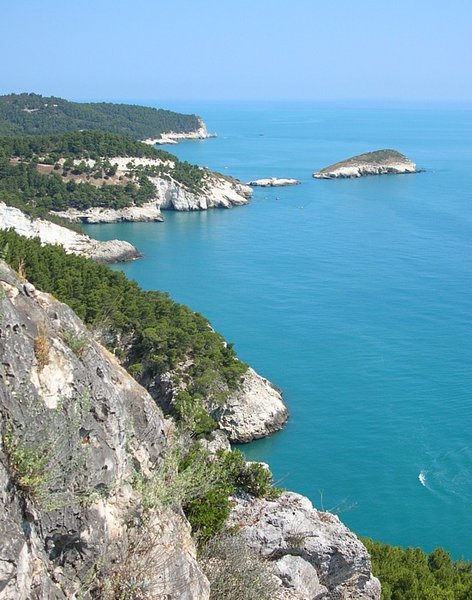
The Foresta Umbra is a quiet, ancient beech forest offering shaded, easy trails away from the coast. The Vieste cliff coast trail delivers moderate elevation changes with views of limestone sea stacks. The park’s mix of forest and coastline provides a diverse hiking experience. Monte Sant’Angelo adds cultural interest with its grotto sanctuary. This park balances alpine terrain with Mediterranean coastal features.
Located on the ‘spur’ of Italy’s boot, Gargano is accessible by road from Bari or Foggia. The park is less crowded than Salento, but weekends can bring local visitors. The Foresta Umbra trail is best early to avoid afternoon heat. The main caution is the long drives between coastal and forest zones, so plan accordingly to avoid wasting daylight.
- Region: Puglia
- Area: 1180 km2
- Best time: May to June and September to October
Wildlife to look for: Italian wolf · Golden eagle · Mouflon sheep · Ancient beech trees
What to do: Hike Foresta Umbra circular (easy) · Hike Vieste cliff coast trail (moderate) · Explore Monte Sant’Angelo sanctuary · Photograph Faraglioni sea stacks
Why it earns the detour:
- Foresta Umbra offers quiet, shaded forest hikes rare in southern Italy.
- Vieste cliff trail combines moderate hiking with dramatic sea views.
- Monte Sant’Angelo’s sanctuary adds historical depth to the visit.
- Faraglioni di Pugnochiuso sea stacks are a distinct coastal feature.
- Less crowded than Salento, making it easier to find solitude.
Insider tip
Start the Foresta Umbra trail at dawn to enjoy cool temperatures and silence before day visitors arrive.
Aspromonte National Park, Calabria- Region: Calabria
- Area: 644 km2
- Best time: May to June and September to October
Verdict
Aspromonte is for experienced trekkers seeking raw wilderness and cultural depth, but requires a 4WD and patience. Skip if relying on public transport or easy access.
Aspromonte’s rugged terrain includes the 1,955m Montalto summit, the park’s highest point. The landscape is wild, with dense Pinus laricio forests and remote Grecanico villages preserving ancient Greek language and culture. Hiking here is physically demanding and navigation can be tricky. The park offers a layered experience combining nature and cultural immersion, but it is not for casual visitors.
Located at Italy’s southern tip, Aspromonte is remote with limited public transport. A 4WD vehicle is essential to reach trailheads and villages. The park is quiet year-round but expect rough roads and sparse facilities. The main caution is the physical challenge of the Montalto summit hike and the need for self-sufficiency in this wild area.
- Region: Calabria
- Area: 644 km2
- Best time: May to June and September to October
Wildlife to look for: Calabrian black squirrel · Golden eagle · Pinus laricio forests · Grecanico village fauna
What to do: Climb Montalto summit (hard) · Explore Grecanico villages · Forest hiking · Wildlife spotting
Why it earns the detour:
- Montalto summit is a tough climb rewarding with expansive views.
- Grecanico villages offer a rare cultural experience with preserved language.
- Dense pine forests create a true wilderness atmosphere.
- Remote location means few visitors and no crowds.
- Requires 4WD and good planning for access and safety.
Insider tip
Use a 4WD to reach trailheads early and avoid long hikes starting late in the day on the Montalto summit route.

Monti Sibillini National Park, Marche / Umbria- Region: Marche / Umbria
- Area: 700 km2
- Best time: June to September
Verdict
Monti Sibillini is the alpine park to anchor a northern Italy trip around, with challenging hikes and the seasonal Piano Grande bloom. Ideal for fit trekkers seeking varied terrain and cultural highlights.
The park’s defining feature is the Piano Grande plateau, which explodes in color during the late June lentil bloom. Monte Vettore, at 2,476m, offers demanding summit hikes with rewarding views. Trails like the Lago di Pilato circuit are hard but showcase rare alpine lakes and endemic species. The park blends high mountain terrain with pastoral landscapes and small villages, making it a complete trekking destination.
Access is via small towns like Castelluccio, which suffered earthquake damage but is reopening gradually. The park is busiest during the bloom but otherwise quiet. Trails vary from easy loops to hard summit climbs. Weather can change rapidly at altitude, so prepare accordingly. The main caution is the ongoing recovery from the 2016 earthquake, which affects some facilities and trail conditions.
- Region: Marche / Umbria
- Area: 700 km2
- Best time: June to September
Wildlife to look for: Apennine wolf · Golden eagle · Chirocephalus marchesonii brine shrimp · Alpine wildflowers
What to do: Hike Lago di Pilato circuit (hard) · Hike Piano Grande loop (easy) · Summit Monte Vettore · Photograph lentil bloom
Why it earns the detour:
- Piano Grande lentil bloom is a rare natural spectacle in late June.
- Monte Vettore is the highest peak with challenging alpine trails.
- Lago di Pilato circuit offers a hard hike with unique endemic species.
- The park combines alpine terrain with pastoral and village landscapes.
- Earthquake recovery means some trails and facilities are limited.
Insider tip
Time your visit for late June to catch the lentil bloom and hike the Piano Grande loop early in the morning to avoid heat and crowds.

Tuscan Archipelago National Park, Tuscany- Region: Tuscany
- Area: 180 km2
- Best time: May to June and September to October
Verdict
Base yourself on Elba for accessible alpine hiking and use permits to explore Capraia and Pianosa for remote island trekking. Avoid July and August due to high prices and crowded ferries.
Elba island offers the Monte Capanne summit hike with moderate difficulty and alpine terrain. The park’s other islands, like Capraia and Pianosa, require permits and offer more isolated experiences with fewer visitors. The marine park protects monk seals and dolphins, adding a marine dimension to the hiking. The archipelago combines mountain hiking with island landscapes, ideal for trekkers wanting variety.
Elba is reachable by ferry from Piombino and serves as the practical base. Capraia and Pianosa require advance permits and have visitor caps. July and August see ferry prices triple and beaches saturate, so plan for shoulder seasons. The main caution is ferry schedules and permit availability, which can limit spontaneous visits to the smaller islands.
- Region: Tuscany
- Area: 180 km2
- Best time: May to June and September to October
Wildlife to look for: Monk seals · Bottlenose dolphins · Mediterranean shearwaters · Island endemic plants
What to do: Hike Monte Capanne summit (moderate) · Island hopping with permits · Snorkeling in marine zones · Explore Capraia trails
Why it earns the detour:
- Monte Capanne is a solid alpine hike with panoramic views on Elba.
- Capraia and Pianosa require permits, limiting visitor numbers.
- Marine park status protects monk seals and dolphins.
- Ferries from Piombino make Elba accessible for day trips or stays.
- Avoid peak summer months to save on ferry costs and avoid crowds.
Insider tip
Book permits for Capraia and Pianosa well in advance and plan ferry trips early in the day to maximize island time.

Vesuvius National Park, Campania- Region: Campania
- Area: 87 km2
- Best time: April to June and September to October
Verdict
Combine Vesuvius with Pompeii or Herculaneum for a half-day alpine hike with cultural depth. The summit walk is short and easy but expect crowds; skip if seeking solitude or long alpine treks.
Vesuvius offers a 90-minute round-trip hike to the summit crater rim at 1,281m, providing views over the Bay of Naples and the volcano’s caldera. The park is compact and best combined with archaeological visits to Pompeii or Herculaneum. The trail is well maintained and suitable for most fitness levels. The volcano’s active status adds an edge but does not affect the short hike.
Access the park shuttle from Ercolano station, which drops visitors at 1,000m. Entry costs approximately €13 and includes a guided walk to the summit. The park is busy year-round, especially weekends and holidays. The main caution is the large number of visitors and the risk of volcanic activity, though the last eruption was in 1944.
- Region: Campania
- Area: 87 km2
- Best time: April to June and September to October
Wildlife to look for: Wild boar · Apennine hare · Mediterranean lizard · Volcanic flora
What to do: Hike Gran Cono summit crater rim (easy) · Visit Pompeii archaeological site · Visit Herculaneum archaeological site · Take park shuttle from Ercolano
Why it earns the detour:
- Short, accessible hike to an active volcano summit.
- Combine with Pompeii or Herculaneum for a full cultural day.
- Park shuttle reduces uphill walking and parking issues.
- Volcanic landscape offers unique flora and geological features.
- High visitor numbers require early arrival to avoid crowds.
Insider tip
Use the shuttle from Ercolano station to save energy for the summit walk and avoid parking hassles.

Other national parks worth knowing
Italy runs 25 national parks in total, and the ones below did not make the cut here mainly on reach or infrastructure, not on scenery. Worth a look if your route already passes nearby.
- Sila National Park – a high plateau in Calabria known for dense pine forests and a cooler climate than the coast below.
- Cilento, Vallo di Diano and Alburni National Park – a large Campania park mixing limestone mountains with a coastline near Paestum.
- Val Grande National Park – Piedmont’s wildest corner, a roadless wilderness near Lake Maggiore for experienced hikers.
- Majella National Park – an Abruzzo massif riddled with hermit caves and high-altitude trails above 2,000m.
- Foreste Casentinesi National Park – ancient beech and fir forests straddling Tuscany and Emilia-Romagna.
- Alta Murgia National Park – a Puglia plateau of dry grassland and Frederick II’s Castel del Monte.
When to go, and what to do if your dates are fixed
Timing is crucial for maximizing your experience in Italy’s national parks. Each season brings unique opportunities and challenges, influencing wildlife sightings, trail accessibility, and crowd levels. Understanding these seasonal dynamics helps in planning an efficient and enjoyable trip.
The summer season, and why it is busy
June to September
This period offers the best weather for hiking and wildlife viewing, with trails fully accessible. However, expect large crowds, especially in popular parks like Gran Paradiso and Stelvio. To avoid the busiest times, plan your visits for weekdays and early mornings. If you prefer solitude, consider exploring less-trafficked parks like Dolomiti Bellunesi.
The shoulder season, and why it is ideal
May and October
These months provide a balance of pleasant weather and fewer visitors. Wildlife is active, and trails are less crowded, making it an excellent time for hiking. However, some higher-altitude trails may still have snow in May, so check conditions beforehand. October offers stunning autumn colors, particularly in parks like Abruzzo, Lazio and Molise.
- Lentil bloom in Castelluccio – Late June to early July
This natural event transforms the landscape into a vibrant display of colors, making it a photographer’s dream. Parks: Monti Sibillini National Park
Navigating crowd levels
Avoid weekends and local holidays, as these times see an influx of domestic tourists. The peak foreign tourist season typically aligns with summer months, particularly July and August. To experience the parks with fewer people, aim for visits during the shoulder months of May and October.
Some links on this page are affiliate links. We may earn a small commission at no extra cost to you when you book through them.